
First Nor’easter of 2014-15 Season
October 27, 2014 by Chris Hein
Williamsburg, VA
The storm that rolled through New England last week marked the first nor’easter of the 2014-15 storm season. Yea!(?)
Local reports indicate that damage was not terribly extensive. No major scarping in front of homes, certainly no homes lost. This is all great news. However, if you make it out to the beach in the next days, look for other ominous signs of its effects. The beach has spent the last six months building vertically (accreting) and widening (prograding). This produces a nice high, wide berm (where you park your beach blanket on a summer day) above high tide. This is called the “summer” beach profile.
A typical effect of the first storm of the year is to erode away the berm and flatten the overall beach, leaving a “winter” profile. Check out these images (from the Maine Department of Conservation) for a comparison of summer and winter beach profiles:
So what, this first nor’easter eroded away the beach berm and flattened the beach? It is a completely natural and expected process. Beaches are always coarser and flatter in the winter. Well, this summer profile is the first line of defense against wave attack. With this gone, it leaves the remaining beach and dunes more vulnerable to waves from the next storm. If there is a long enough period in between storms the beach can recover some of its “summer” profile and the next moderate storm will have a minimal impact. However, if the next one comes too soon while the natural defenses are still weak, then even a small to moderate storm can have severe impacts.
Of course, my thoughts here on the impacts of this first storm are somewhat speculative – based on newspaper reports, sparse photos, and my knowledge of coastal processes. I have not actually seen the impacts of the storm. One of the most challenging aspects of studying a barrier island in Massachusetts, while living in Virginia, is how hard it is to get to the site. I’ve done that 12-hour drive enough times in the last year (10 round trips maybe?) to know how painful traffic in and around DC, Baltimore, New York, New Haven and Boston can be!
As a field geologist, it is crucial to get out and walk the beach to truly understand how it is changing. Since that is not possible due to time and money constraints (and my teaching schedule here at VIMS . . . though I am sure my students would not be too upset if I missed a few days of class), I am relying on the observations of those who can get to the beach and see what has changed. Andy will be up on Plum Island in early November doing his monthly survey – certainly the impacts of this storm will be seen in those data. However, in the meantime, if you are reading this and have some pictures or observations you would like to share, please email me ([email protected]). I’ll be glad to post anything to the blog as well if you would like to share more broadly!
Here’s hoping that this is one of very few nor’easter blog posts I write this winter storm season!
– Chris
Plum Island Geologic Field Trip!
October 14, 2014 by Chris Hein
Boston, MA
Last Friday, I and my students from VIMS (Claudia, Luis, Charlie, and Justin) ran a field trip (co-organized with Byron Stone of the USGS) to the lower Merrimack River Valley and Plum Island. This field trip was attended by ~50 geology students, scientists and professors (mostly from New England, but also from Canada and Brazil) as part of the 106th meeting of the New England Intercollegiate Geological Conference (NEIGC). This is the oldest geological conference in the USA – a real honor to be a part of!
The trip ran from Haverhill, MA, down the lower Merrimack River valley, and onto Plum Island. It included several stops in the Parker River National Wildlife Refuge and at Sandy Point State Park. Participants got to help run ground-penetrating radar and open a sediment core on Plum Island (one of the cores we took back in May).
Northeastern Massachusetts treated us to some perfect October weather as we explored the glacial, post-glacial and coastal deposits that fed the formation of the beaches at the mouth of the Merrimack River. A perfect day for all to dig into the spectacular scenery and geology of Plum Island!
A link to download the field trip guide can be found HERE. It can also viewed online at the VIMS Coastal Geology ISSUU site HERE.
NEIGC Field Trip Photo Gallery
October 13, 2014 by Chris Hein
Here are a bunch of photos taken by William & Mary geology student Charlie Deaton during the Plum Island section of the NEIGC field trip last Friday. We’ll post more photos as we get them!
Monthly Beach Mapping
October 1, 2014 by Chris Hein
Gloucester Point, VA
One of the primary goals of this project is to understand what is driving the natural cycles of beach erosion and widening (what coastal geologists call “accretion” or “progradation”). The first step is to get a quantitative handle on just how much sand is moving onto, off of, and along the beach due to natural seasonal cycles.
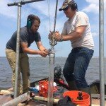
To that end, my masters student, Andy Fallon (shown on the right walking with project investigator Peter Rosen along the dune toe in front of Annapolis Way), is mapping the Plum Island beach on a monthly basis using a Global Positioning System with Real-Time Kinematics (RTK-GPS). Once a month, early in the month, you will find Andy out there walking the beach with a rod with what looks like a small UFO on top. He is carrying around a “rover” antenna on top of a rod of known height. This antenna talks (via radio) to our “base station” antenna that is generally set up on a tripod on the deck of a Plum Island homeowner (Bob Connors of Annapolis Way – thanks Bob!). The base station sits for hours at a time and constantly improves its positioning accuracy. It then corrects the data from the rover. The end result? Andy can record his position as well as the elevation of the antenna to within about 1 inch (your car GPS is accurate to about 10 feet . . . though the elevation can be off by dozens of feet). He collects that data every 1 foot that he walks, collecting tens of thousands of data points along the dune toe, the low tide line, several lines along the beach in between, and then a series of “crossing lines” that he walks diagonally between the dune toe and the low tide line.
From these data, Andy is going to create high-resolution topographic maps (what we call “digital elevation models” or DEMs) of the 1.6 miles of beach from the jetty at the mouth of the Merrimack River all the way south to the border between the town and the Parker River National Wildlife Refuge. Check out the first example, from May 2014, in the figure below. By comparing these maps from different months, we will be able to look at how the beach is changing during the seasons and actually calculate with high precision the volumes of sand that move onshore, offshore and alongshore during the year. This will give us a first clue into the natural changes along the beach due to winter storms, hurricanes (though we are all hoping we don’t see one of those this year!), and calm-weather beach-building processes, like those bars of sand that you would see moving onshore if you were out on Plum Island at low tide this week.
The image above shows a map of Plum Island showing elevation data collected in May 2014 along northern Plum Island. The right-hand side of the image shows a three-dimensional view of the beach at that time. Warm colors are higher elevations and cold colors are low elevations. Note the deep erosion right in front of Annapolis Way at the erosion “hotspot”. Figure is from: Fallon, A.R., Hein, C.J., and Rosen, P.S., submitted abstract, Cyclical shoreline erosion: The impact of a jettied river mouth on the downdrift barrier island: Coastal Sediments 2015 (San Diego, CA, May, 2015).
Recent Posts
Dispatch from the Field
 June 14, 2015 - Rowley House, Rowley, MA One week down . . . one to go. Claudia, Justin, and I are at the half-way point of a major […]
Plum Island Research Team Presents Results at International Conference
 May 15, 2015 - Williamsburg, VA I am just back from beautiful, sunny San Diego! Andy Fallon and I were out there all of this past week at the […]
Plum Island Research Featured in Public Radio Interview
April 21, 2015 - Gloucester Point, VA Chris was interviewed by the public radio program “With Good Reason” in an interview that aired last week. The discussion centers around […]
Recent Library Uploads
Dispatch from the Field
Posted: June 14, 2015
Rowley House, Rowley, MA One week down . . . one to go. Claudia, Justin, and I are at the half-way point of a major […]
Plum Island Research Team Presents Results at International Conference
Posted: May 15, 2015
Williamsburg, VA I am just back from beautiful, sunny San Diego! Andy Fallon and I were out there all of this past week at the […]
Fallon Coastal Sediments 2015 Paper – Cyclical Shoreline Erosion on Plum Island
 Posted: May 15, 2015
Fallon Coastal Sediments 2015 Paper – Cyclical Shoreline Erosion on Plum Island PDF of the paper presented by Andy Fallon at the 2015 Coastal Sediments […]
Plum Island Research Featured in Public Radio Interview
Posted: April 21, 2015
Gloucester Point, VA Chris was interviewed by the public radio program “With Good Reason” in an interview that aired last week. The discussion centers around […]