
Plum Island Research Team Presents Results at International Conference
May 15, 2015 by Chris Hein
Williamsburg, VA
I am just back from beautiful, sunny San Diego! Andy Fallon and I were out there all of this past week at the Coastal Sediments conference. While I gave a talk about my work on the beaches of Brazil, Andy had the opportunity to present on the work he has been doing towards the completion of his masters thesis – work focused entirely on the erosion problem on Plum Island.
Andy presented some very neat and exciting results looking at the long-term changes along the shoreline of northern Plum Island. By mapping old high-water lines from aerial photographs, satellite imagery, and maps, he discovered that the shoreline of Plum Island undergoes periodic shifts. As anyone living on Plum island knows, the beach is often quite wide all along the northern part of the island. However, once every 25-40 years, it undergoes periods of erosion. Andy observed these in 1912, the mid-1950s, the late 1970s, and of course this most recent period of erosion which started at Center Island in 2008 and continues today south of Annapolis Way and towards the entrance to the Parker River National Wildlife Refuge. In other words – the erosion we see today has happened before . . . and will likely happen again.
Each time the beach erodes, local homeowners and the towns jump in to help alleviate the problem and protect property: the groins in the 50s and 70s, the rip-rap revetments of the 70s and the last few years, the beach-scape and coir bags on 2008-2010. One of the interesting things Andy has found is that even though some of these measures help in the short-term, they can cause lasting damage. For example, it appears (we’re not yet certain, but the evidence suggests) that the groins along Plum Island (note, the groins on the beach, NOT the jetties at the river mouth inlet) might be exacerbating the erosion problem. More to come on this later once we’ve had a chance to better analyze the data.
Andy also presented on his short-term mapping work – the 14 months of beach mapping he has been doing (see more on that in this post from October 2014). Andy has observed the “hoptspot” of erosiion shift from Annapolis Way south. He has also observed (and quantified the volumes of sand!) large seasonal variability in the size of the Plum Island beach. We know this happens (see this post from last fall), but now we have numbers to do what scientists do best – quantify it! The most impressive result? The erosion “hotspot” overwhelms the seasonal variability. We know this thing is serious from all the houses it has taken in . . . now we can show just how large the hotspot is and how much sand it takes away when it comes to town.
One of the most important jobs we have as scientists is presenting the results of our work to our peers – that is how science builds and how we can apply the lessons from Plum Island to beaches across the world. There were ~400 people at this recent conference we attended, representing 37 countries! The story of Plum Island is spreading.
We’ll have more on the final results of Andy’s work on this site in the future. However, if you are interested to learn more about what he presented at this conference, you can download his conference paper here and view a PDF of the powerpoint presentation he gave here.
A short weekend in Virginia and then a bunch of us are heading up to Massachusetts on Monday for field work in the Great Marsh behind Plum Island. We’re renting a house for the week on Plum Island, so if you see us around, please stop by and say hello.
 December 2, 2015 - VIMS, Gloucester Point, VA As the title says, it’s been a while. Sorry about that – this semester has been very busy. But, I wanted […]
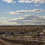 August 26, 2015 - VIMS, Gloucester Point, VA The VIMS team is back home after a lot of field work and meetings this summer . . . and none […]
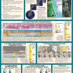 Posted: February 21, 2016
 Posted: December 2, 2015